

Turbulent air-flow and wind conditions caused by the individual complex topography of these areas confront planners and manufacturers with particular challenges that may prove critical for project realisation. This applies all the more because no two sites are the same, so that reference energy yield cannot simply be taken over from other projects.
Depending on wind direction and speed, topographic formations in the direct vicinity such as hills, valleys or forest tracks may cause 'jet effects' or wakes, significantly influencing the wind conditions prevailing at the site in question.
Nevertheless, legal framework conditions, technological innovations and high towers have paved the way for a rise in the number of wind farms planned in the forests of minor mountain ranges in Germany.
These factors have enabled rotors to reach great heights where wind velocities are high and turbulence low. However, as foundations and towers grow so do project costs, making profitability analysis for these sites far more complex.
For each and every site, project owners must ask themselves the following key question: "Is profitable wind-turbine operation possible at this site, or may the costs incurred for construction, maintenance and repair threaten to spiral out of control?" To answer this question, stakeholders need reliable calculations of future annual output and turbulence intensity.
Quality of output prediction is of critical importance
Although today's high-performance 3D simulation models enable a site's potential annual output to be calculated with extreme precision, simulation results are only as good as the data used in the calculations.
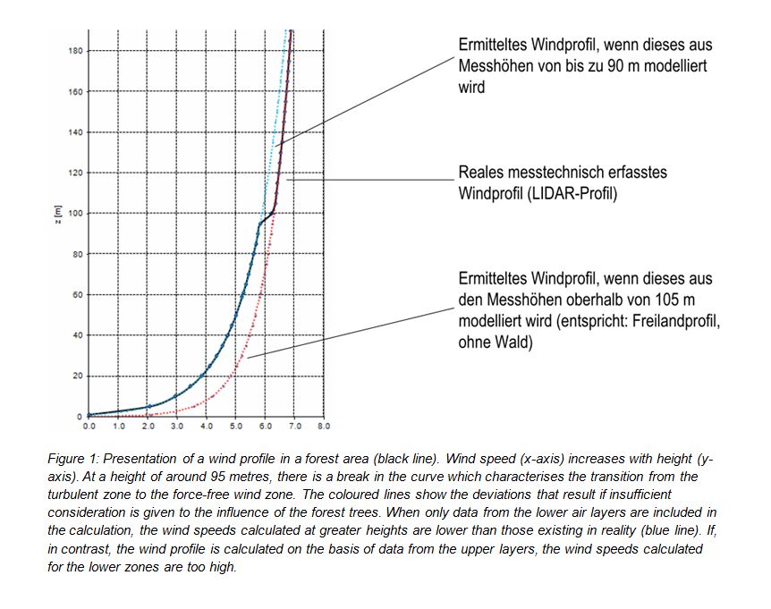
However, many regions in Germany lack validated wind data as sites in forests and minor mountain ranges have only very recently moved into the focus of stakeholders' interest. In those rare cases where measured data are available, they often do not extend to the required height: wind monitoring masts in the past were rarely higher than 80 metres, so that these data are unsuitable for determining the actual conditions in higher zones.
Sites on complex terrain require hub heights of at least 120 metres and rotors that do not reach down to the turbulent zones above the top of the trees and mountain ranges. Given this, reasonable and robust planning will aim at placing the lower edge of the turbine's rotor blade at a height of around 2.5 to 3 times the height of the trees of the forest. Swirling winds and critical turbulence cause vibrations of the rotor blades, exposing them to significant stresses and adversely affecting the stability and service life of wind turbines and their components. Consequences include turbine failure and cost-intensive maintenance measures and repairs.
This is another reason for higher demands on profitability; increases in output essentially depend on the rotor diameter and can only be realised by using larger rotors, which in turn also require higher hub heights. Given this, errors and standard deviations in predictions of wind and output must obey narrow limits to ensure a solid basis for planning.
Wind measurements in accordance with IEC 61400 indispensable
Given this, the planning of a wind farm depends critically on a detailed picture of the wind conditions that prevail at hub height at the respective site. Precise measurements in accordance with recognised standards such as the IEC 61400 thus form the basic prerequisite of a reliable yield forecast.
To determine these wind conditions in long-term measurements, a wind monitoring mast with calibrated cup anemometers is installed at the planned site and measures and records the wind profile up to hub heights. In the Bavarian region of Upper Palatinate,
TÜV SÜD is presently carrying out this type of measurement within the framework of a research project to obtain solid data on wind conditions at heights of 140 metres. Together with the local energy initiative Natural Energy Solutions (NES), which is planning a wind farm comprising up to six wind turbines in a forest area near Erbendorf, the wind professionals installed a 140-metre research met mast and put it into service last October.
Over the next two years, a total of eight calibrated cup anemometers and further sensors will record all relevant data including wind speed, wind direction, temperature, atmospheric pressure and humidity, thus painting a detailed image of the wind profile.
In addition to the calculation of mean annual wind speeds and mean annual energy output, the measurements also permit analyses of turbulence, wind shear and extreme winds to be carried out for different heights and permit a solid assessment of the profitability of the planned wind farm to be drawn up.
As reference values, they further permit measurements conducted at lower heights to be extrapolated and detailed studies of the impacts of turbulence and topography to be made. The project will thus also supply basic findings for wind-farm projects in other forested areas on minor mountain ranges.
The example shows the important role that site-related measurements play as a basis for planning. Wind resource analysis is therefore a basic requirement for a bankable wind and energy production report, which in turn provides the basis for project-related economic modelling. The German Federation of Wind Power (Fördergesellschaft Windenergie, FGW) requires long-term measurement to be carried out (over at least 12 full months) using a monitoring mast of at least 2/3 of the planned hub height.
Additional measurements carried out by LIDAR systems
Instead of a wind monitoring mast that reaches up to hub height, a smaller wind mast can be used and the data measured by this mast supplemented with additional measurements carried out by other systems.
The FGW standard recommends using a measurement mast that reaches up to at least two-thirds of the hub height. However, vertical measurement based solely on such a 'two-thirds measurement' involves a higher level of uncertainties, particularly in forested areas, as there may still be a vertical distance of as much as 40 to 50 metres between the top measurement point and the planned hub height.
In this case, a LIDAR (light detection and ranging) system can be used to measure and supplement the missing wind data from higher atmospheric layers. A LIDAR system installed at ground level enables wind velocities and directions to be measured at heights of between 40 and 250 metres.
Measurement points can be defined in the vertical plane at a resolution of approximately 20 metres and put into relation to the calibrated reference values of the measurement mast. By combining measurement mast and LIDAR system data, the wind profile can be determined in detail at distances beyond the hub height.
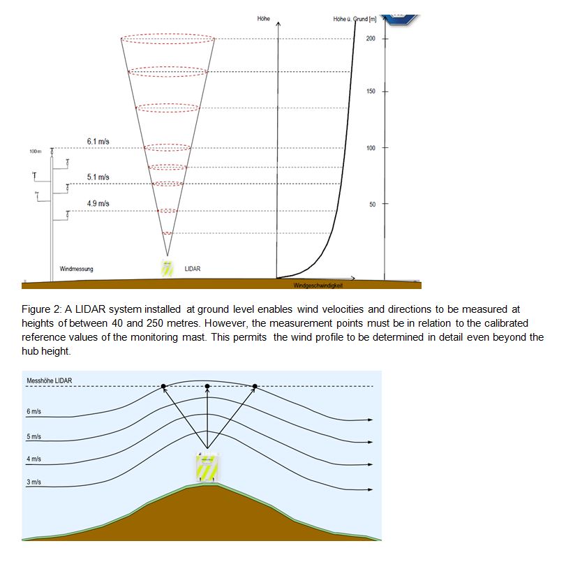
The device's working principle is based on ultra-short laser pulses that are sent into the atmosphere. The photons emitted by the system are scattered by aerosols and dust particles in the air flow. The backscattered photons are collected on the LIDAR telescope and registered by a highly sensitive detector. T
he LIDAR system uses these signals to make high-precision calculations of wind direction and velocity based on changes in frequency and signal runtime (Doppler effect). In combination with the simultaneously determined exact reference data of anemometer measurements, the wind profile can be extrapolated up to the heights of the upper tip of the rotor blade.
The data thus offer a reliable basis for subsequent wind-resource and profitability analyses, enabling the possible energy output to be predicted and quantified with the maximum accuracy.
The right mix is the key to success
However, when using LIDAR systems to analyse wind conditions some aspects must be taken into account. Purely relative measurement values, for example, are not very informative. Only when the data are linked with those supplied by the calibrated sensors can the calculations for wind, turbulence and extreme wind reports deliver exact results. Precise reference values are also required for the subsequent measurement and verification of the wind turbine's power curve.
Since long-term measurements with the mobile and flexible LIDAR systems are relatively expensive, a period must be determined for which measurements must be performed to represent a solid measurement series.
Professionals recommend continuing measurements until all atmospheric conditions, i.e. unstable, neutral and stable weather conditions, have been covered. Three months of LIDAR measurements may be sufficient for this purpose.
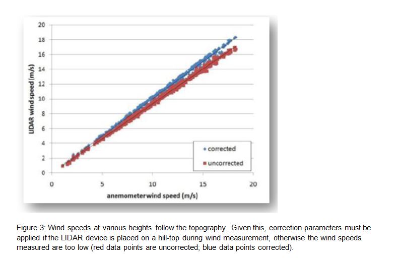
In hilly terrains, stakeholders must take into account that the LIDAR system emits its laser pulses into the sky in a cone shape, while the measurement points are at one and the same horizontal level and thus lie in the cone's circular cross-section.
In uneven terrain this may result in incorrect values since wind speeds at various heights follow the topography. Given this, the values at the centre of the cone measured by a LIDAR system installed on a hilltop, for example, would be too low. Because of this, it is important to include the topography and ascents in the terrain in the calculations by applying correction parameters.
The right simulation model
Once the raw data are available, they are input into a digital simulation model which calculates the possible energy output. Careful choice of the most suitable simulation model from those available on the market is essential.
While two-dimensional simulation models, such as the "Wind Atlas Analysis and Application Program" (WAsP), developed by the Technical University of Denmark in Risø, are sufficient for lowland areas, they produce excessive errors and standard deviations when applied to complex and hilly terrain as they do not consider the topographic influencing factors. As a result, yield predictions and profitability analyses can no longer be used reliably as bankable reports, but are reduced to mere forecasts that involve a high level of uncertainty.
By contrast, 3D simulation tools such as WindSim enable complex topographic data from GIS systems to be included, ensuring that wind conditions are described with a sufficient level of accuracy. This delivers an improved data set for use as a basis for wind resource analysis and yield prediction.
TÜV SÜD's experts review whether complex calculations using more elaborate 3D simulations make sense for a potential wind site, including consideration of economic perspectives in the process. Given this, experts must ask themselves whether 2D simulation is sufficient or whether the terrain is so complex that 3D simulation is required.
To find the answer, in the run-up to modelling TÜV SÜD's wind power experts describe and assess the roughness of the terrain with the help of the Ruggedness Index (RIX) over an area of 20 x 20 kilometres. The expert also carries out detailed calculation and examination of the gradient in a radius of 3,500 metres around the wind turbine. The resulting RIX value is determined using a 15-point scale which indicates the percentages of the area around the wind turbine that exceed defined levels of steepness.
For values from 0 to 5, 2D simulations are fully suitable; for values between 6 and 10, correction factors and adjustment parameters must be taken into account when 2D simulation is used, and therefore 3D simulations already offer advantages at these values. For calculations in forested regions, for example, the hub height can be reduced by virtual methods. However, if the RIX value exceeds 11, application of a 3D simulation is recommended.
Conclusion
Predictions of energy output and profitability play an important role in keeping the financial risks involved in a wind farm project to a minimum. Wind conditions in forest areas of minor mountain ranges in Germany are complex, and planning, construction and operation of the plants are cost-intensive. Standardised wind measurements carried out with a monitoring mast, which can be complemented by state-of-the-art laser methods under certain conditions, deliver a solid set of data that can be used as a basis for further analysis. In cases involving complex terrain, choice of the most suitable simulation model is also important. Today, adequate tools are available that enable solid wind data to be collected over the medium term for forest areas and minor mountain ranges in Germany. The development of these sites will increasingly turn into an important pillar of the energy transition as available sites on restriction-free open lowland areas become scarcer.
About the author:
Dipl.-Ing. Peter H. Meier, TÜV SÜD Industrie Service GmbH, Wind Cert Services. Contact: peter-h.meier@tuev-sued.de
For additional information: