
But these inaugural glimpses go beyond forests. Remarkably, the satellite is already showing potential to unlock new insights into some of Earth’s most extreme environments.
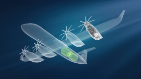
Biomass – an Earth Explorer research mission developed within ESA’s FutureEO program – was launch less than two months ago. This new mission is, therefore, still in the process of being commissioned, but its first set of images are stunning none the less.
ESA’s Biomass Project Manager, Michael Fehringer, commented, “As is routine, we’re still in the commissioning phase, fine-tuning the satellite to ensure it delivers the highest quality data for scientists to accurately determine how much carbon is stored in the world’s forests.
“Biomass is equipped with novel space technology, so we’ve been closely monitoring its performance in orbit, and we’re very pleased to report that everything is functioning smoothly and its first images are nothing short of spectacular – and they’re only a mere glimpse of what is still to come.”
Biomass is the first satellite to carry a P-band synthetic aperture radar, its signal capable of penetrating forest canopies to measure woody biomass – trunks, branches and stems. These measurements serve as a proxy for carbon storage, the assessment of which is the mission’s primary objective.
While it settles into its life in orbit, ESA’s pioneering Biomass mission is already returning data. The satellite, its instrument and systems are still being calibrated so these first data cannot yet be used to quantify carbon or support scientific advances, but they do show that Biomass is well on track to achieving its goals.
ESA’s Director of Earth Observation Programmes, Simonetta Cheli, said, “Looking at these first images, it’s clear to see that our Earth Explorer Biomass satellite is set to deliver on its promise.
“We fully expect that this new mission will provide a groundbreaking leap in our ability to understand Earth's forests – combining cutting-edge radar technology with the scientific excellence that will unlock vital insights into carbon storage, climate change, and the health of our planet’s precious forest ecosystems.”
Biomass' first image features part of Bolivia. Bolivia has experienced significant deforestation, ranking among the highest globally for primary forest loss. Although there are complex reasons at play, this is primarily driven by forest clearance for agricultural expansion.
This vibrant image was created using the radar instrument’s different polarization channels, with each color revealing distinct characteristics of the landscape. For instance, green hues mainly represent rainforest, red hues forested floodplains and wetlands, and blue–purple is indicative of grasslands, while black areas are rivers and lakes.
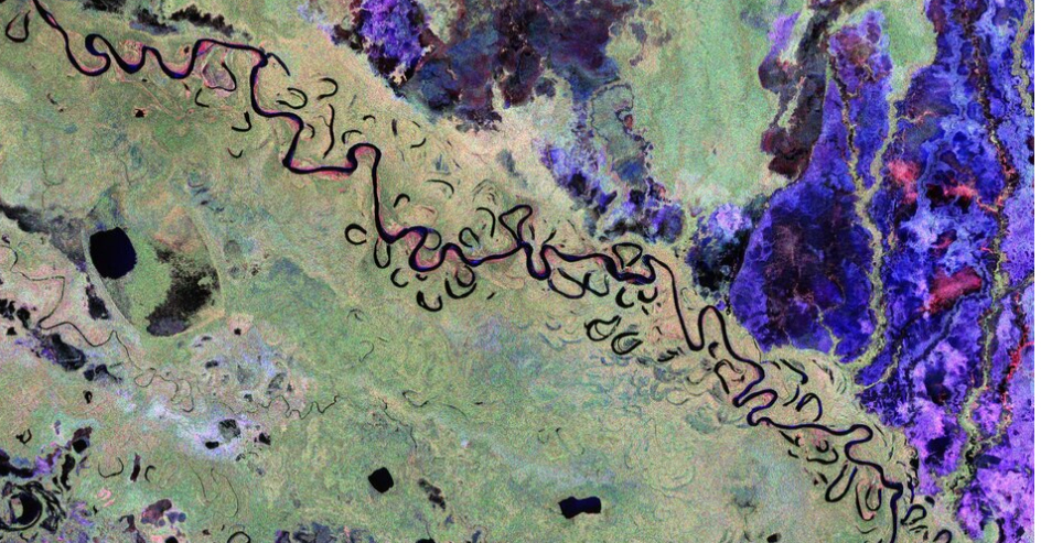
In the Amazon Basin, some rivers run wild – unhindered by dams, they are free to meander, but some more dramatically than others. The image captures one such wanderer, the Beni River, which flows from the Andes Mountains across the Bolivian lowlands northeast towards Brazil.
The true strength of the Biomass mission lies not in identifying features from a single image, but in its unique sampling technique and ability to combine multiple observations of the same area to reveal forest height and biomass. This enables scientists to accurately quantify forest carbon stocks and better understand the role of tropical forests in the global carbon cycle.
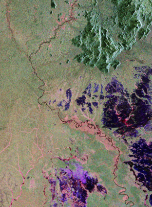
Another image is actually the very first acquisition that Biomass returned. It offers another striking view of the Amazon rainforest, but this time over northern Brazil.
In the southern part of the image, pink and red hues reveal the presence of wetlands, highlighting Biomass’ ability to penetrate dense vegetation and detect features down to the forest floor. The dominance of red tones along river indicates forested floodplains, while the northern area, depicted in rich green, reveals more rugged topography and dense, continuous forest cover.
The radar is expected to be able to penetrate through dry sand by as much as five meters. Data can, therefore, be used to map and study sub-surface geological features in deserts, such the remains of ancient riverbeds and lakes. This will help understand the past climate and also help prospect fossil water resources in desert regions.
The long wavelength of Biomass’ radar allows for deeper penetration into ice, enabling the retrieval of valuable information on ice velocity and the internal structure of the ice, capabilities that shorter wavelength radars cannot achieve effectively.